|
Home About UNRBA About the Upper Neuse River Basin
Projects & Activities Downloads Meetings Links |
 |
 |
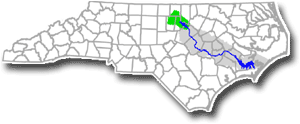 Location of the Upper Neuse River Basin in North Carolina, USA
|
The Upper Neuse River Watershed is located in the Piedmont area of North Carolina. The UNRBA defines the Upper Neuse River Watershed as the 770-square-mile area draining to the Falls Lake Reservoir, Raleigh's major water source.
The watershed is comprised of three major tributaries; the Flat River, the Little River, and the Eno River.
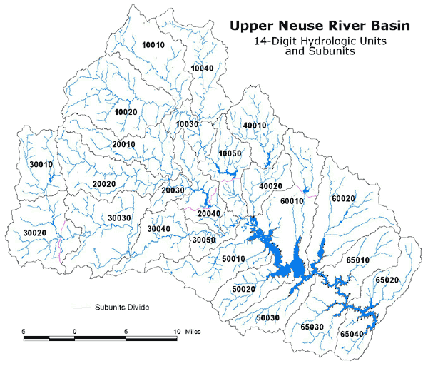
Upper Neuse River Basin
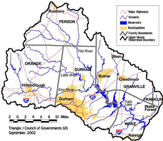
WATER RESOURCES
The Upper Neuse is home to about 190,000 people and contains nine public drinking water supply reservoirs that together serve about 500,000 people. These water supplies are:
- Falls Lake (Raleigh)
- Lake Michie (Durham)
- Little River Reservoir (Durham)
- Lake Holt (Butner/Granville County)
- Lake Orange (Orange County)
- New Hillsborough Lake (Hillsborough)
- Corporation Lake
- Lake Ben Johnston
- Lake Rogers (Creedmoor)
Clearly, the watershed's water resources are essential to the health, safety, and vitality of the region's people, economy, and environment.
WATERSHED CONDITION
The following information about water quality and population growth in the Upper Neuse is from the Upper Neuse Watershed Management Plan, May 2003.
Due to its large area and many communities, conditions in the Upper Neuse River Watershed vary widely from one location to another. The major land cover types of the watershed are forest (61%) and agriculture (16%). Most of this open space is in the headwaters of the Flat, Little, and Eno Rivers. Seventeen percent (17%) of the watershed is urban or suburban. See the Land Use/Land Cover map.
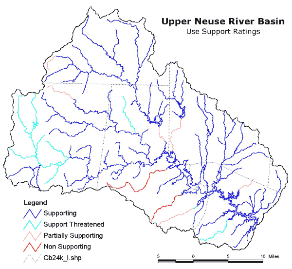
The Use Support map shows streams that are impaired as defined under Section 303(d) of the federal Clean Water Act (2002 listings). The federal government will require that Total Maximum Daily Loads (TMDL) be set for some of these streams. Under a TMDL, a stream must meet standards for improving certain conditions.
POPULATION GROWTH
According to recent estimates, the Upper Neuse River Watershed's population is approximately 190,000 people. Sixty-one percent (61%) of the population lives in Durham City and County, while twenty-four percent (24%) of the population lives in the Orange and Wake County portions of the watershed. Over the next 25 years, population in the watershed is expected to grow by 53% to 280,000 people. The table below shows the projected number of households by Upper Neuse River Basin Communities.
Projected Number of Households in Upper Neuse River Basin Communities:
| Jurisdiction | Year 2000 Number of Households | Year 2025 Number of Households | ||
|---|---|---|---|---|
| Durham County | 16,820 | (21.6%) | 19,330 | (16.1%) |
| Franklin County | 460 | (0.6%) | 1,150 | (1.0%) |
| Granville County | 3,475 | (4.5%) | 5,900 | (4.9%) |
| Orange County | 10,330 | (13.3%) | 13,850 | (11.6%) |
| Person County | 3,120 | (4.0%) | 4,210 | (3.5%) |
| Wake County | 8,620 | (11.1%) | 17,815 | (14.9%) |
| Creedmoor | 370 | (0.5%) | 690 | (0.6%) |
| Durham | 30,620 | (39.3%) | 50,800 | (42.4%) |
| Hillsborough | 2,000 | (2.6%) | 2,860 | (2.4%) |
| Raleigh | 1,170 | (1.5%) | 1,680 | (1.4%) |
| Roxboro | 200 | (0.3%) | 330 | (0.3%) |
| Stem | 65 | ( 0.1%) | 90 | (0.1%) |
| Wake Forest | 150 | (0.2%) | 450 | (0.4%) |
| Butner | 510 | (0.7 %) | 700 | (0.6%) |
| TOTAL | 79,910 | (100%) | 119,855 | (100%) |
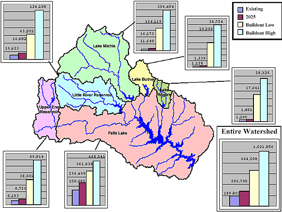
WHERE WILL THE GROWTH OCCUR?
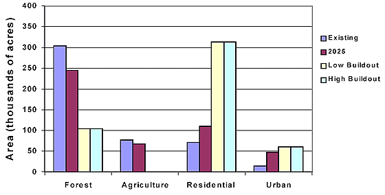
Based upon the existing zoning and development regulations of our local communities, the watershed's population could ultimately triple or quadruple. The figure below shows where growth is expected to occur. This figure shows growth projections for a year 2025 scenario and two "buildout scenarios". The buildout scenarios are projections of what total population could occur at some undetermined time in the future if we build what the local development regulations allow. The low buildout scenario assumes that growth occurs in the low range of existing zoning and watershed regulations, and the high buildout scenario assumes the maximum allowable growth.
LAND USE CHANGES
What will this growth mean for the future of our watershed? Currently, forests (61%) cover the majority of the watershed. Seventeen percent (17%) of the watershed is urban or suburban, and sixteen percent (16%) of the watershed is used for agriculture. By the year 2025, forested area will be lost to development, as the figure below demonstrates. Under both buildout scenarios, agricultural land is lost and forest area greatly reduced, primarily due to residential development.
|
GIS MAPS |
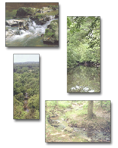
PHOTOS
|
